
Bristol and the clock-making valley
Place — revised 2026-06-30
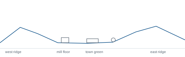
An industry lays out a town and then leaves. The streets stay. They go on explaining an economy that no longer exists, which is why the shape of a place is often the most durable thing about it.
Water first
Central Connecticut's towns were sited on falling water. Before steam and long before electricity, the only way to drive machinery at scale was to put it beside a river with enough drop to turn a wheel, and the Pequabuck and its neighbours in the western hills offered exactly that: modest rivers with usable fall, running through valleys narrow enough to concentrate everything along their floors.
So the works went on the valley floor. The workers' housing went next to the works, because people walked to their shifts. The commercial street ran parallel to both. The larger houses went up the slope, where the air was better and the noise was less. The green and the churches took the level ground slightly above the flood line. That arrangement — water, works, housing, street, slope — is repeated with local variations up and down the region, and it is still perfectly legible on a walk.
Clocks, springs and the habit of precision
The valley's particular trade was small precision manufacturing, clocks above all. Clock-making is an unusual industry to build a town on because it demands interchangeable parts made to fine tolerances in volume, which in turn demands a workforce with specific skills and a dense web of small suppliers doing one operation each.
That structure had consequences for the place. It produced many small and medium works rather than one enormous plant, scattered along the water rather than concentrated in a single site. It produced a habit of precision metalwork that outlived clocks themselves and migrated into springs, ball bearings, tools and later components for other industries entirely. And it produced a settlement pattern of small clusters — a works, a few streets of housing, a corner shop — which is why these towns often read as a chain of villages rather than as one centre with suburbs.
What the streets still say
Walk the older parts of a valley town and the industrial logic is unmissable. Streets run along the contour rather than up it. Housing near the former works is tight, tall and often multi-family, with small yards and doors near the pavement. Move a few hundred metres up the slope and the lots widen, the porches deepen, and the houses acquire the ornament that a supervisor's salary allowed. Keep going and you reach the twentieth-century ring, laid out for cars on land that was farmed while the valley floor was working.
The brick buildings themselves have had several lives. Some were subdivided into smaller industrial tenancies, some converted to flats, some cleared. Their footprints tend to survive even where the buildings did not, because the parcels were awkward shapes that later development worked around rather than through.
The long adjustment
When manufacturing contracted through the later twentieth century, these towns kept the housing and the street pattern of an industrial economy while the employment left. That mismatch is the central fact of the region's recent housing history. It produced a stock that is older and denser than the current pattern of work would produce, priced against a regional economy now oriented toward the corridor cities rather than the valley floor.
It also produced genuine advantages that are easy to overlook: walkable older neighbourhoods, houses built when materials and labour were treated as worth spending, civic buildings of a generosity no comparable town would commission now, and a public landscape of greens, libraries and parks laid out when manufacturing wealth was local.
Reading a place through its industry
The general habit transfers. Ask what the place was for when it was laid out, and the layout stops being arbitrary. A fishing town, a rail junction, a mill village and a farming crossroads each produce a distinctive geometry, and each geometry outlives its purpose by a century or more. Understanding the geometry is most of understanding why the housing sits where it sits.